| Index |
Previous |
Next |
AspEdit manual Border segments
Purpose
In aeronautical publications, airspace boundaries are often defined as follows: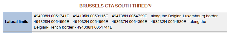
AspEdit allows to define the "along xxx border" segments in a coded form, as follows:
Upon export to OpenAir, all the points on the border segments will be inserted.
Not only borders can be inserted this way, but also other airspace areas.
Inserting a border segment
-
Via the "Block" dialog box
- Copy the entire shape into the input field of the dialog box. Border segments will be recognised automatically. If a default border was specified in the List dialog box, this border will be used. Otherwise "XXX" will be used as border.
- If it is required to manually edit the border, leave the block dialog box, and proceed according steps 4 and 5 of the procedure below to select the shape to be used as border
-
Via the "Add / Edit Border Segment" dialog box
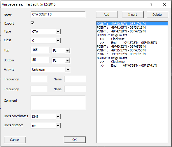
- Make sure that at least one point is defined before the segment. The last point before the segment will be the starting point. The point should be as close as possible on the border, but doesn't need to match exactly.
- In the Area dialog box, press the add or insert button.
- The Add element dialog box will open.
- Select "Border segment", the Border dialog box will open.
- Select the desired shape, specify clock or counterclockwise, and specify the end point.
Modifying a border segment
In the list of the Area dialog box, double-click on any line belonging to the border segment, the Border dialog box will open for the selected segmentClockwise or counterclockwise?
In most geographical software, shapes are turning clockwise as standard. This means that when viewed from the center, the points of the shape are sequenced clockwise. If both the source shape and the shape from which to insert a segment are clockwise, "clockwise" should be selected in the Border dialog box.However, if any shape is counterclockwise, select counterclockwise in the Border dialog box.
In any case, check the results on the map display. If the result is not as expected, invert the selection.
Difference between the border function and the shapes function
- A border segment draws a section of the border shape between two given points.
- The shape function calculates the intersection points between the two shapes, and cuts both shapes at the intersection points. There can be multiple intersecting segments in a single shape operation. For further details, see Adding / subtracting shapes.
Border specifications
Borders can be countries or other airspace areas, also airways or areas consisting of circle, border or shape segments.Countries are located in separate files, see Countries.